A surprise text popped up on my phone last Sunday:
‘Donahue Pass!! on the JMT’.
It was from Alison of course. She had managed to find a cell signal at what is the highest point on her trek so far. A few more messages quickly followed…
‘awesome!! two breakfasts’
‘This is AMAZEBALLS!!!”I am HOME!!!’
I can tell when she is in good spirits. Sometimes by what she says, sometimes by the way she punctuates it! This time it was both. Donahue Pass on the JMT was no typo. The Pacific Crest Trail shares parts of its route with the John Muir Trail. From the point she left Tuolumne Meadows up to Donahue Pass she was retracing steps she had taken back in 2012 when she hiked the 211 mile JMT. That was her first extended solo backcountry hike and served to permanently wet her appetite for these types of big adventures. She has taken many, many backcountry hikes but the JMT was a first for her. From the extended distance and necessity of carefully planned resupplies to the timing of the season to avoid dangerous weather. It launched her into a series of great treks:
•The Drakensberg Grand Traverse in South Africa
•Grande Randonnée Cinq or GR5 in France
•The Colorado Trail
•The Coast to Coast trail in Great Britain
•Paria Canyon to Buckskin Gulch in Utah.
All of these of course were leading up to super big hikes like the Te Araroa in New Zealand and now the PCT. So, you can see how the JMT feels like a homecoming. She asked that I post an update as she heads further into the Sierra Nevada. She retrieved a package last Monday in Mammoth Lakes and immediately headed back to the trail to make some progress during the next few days of favorable weather.
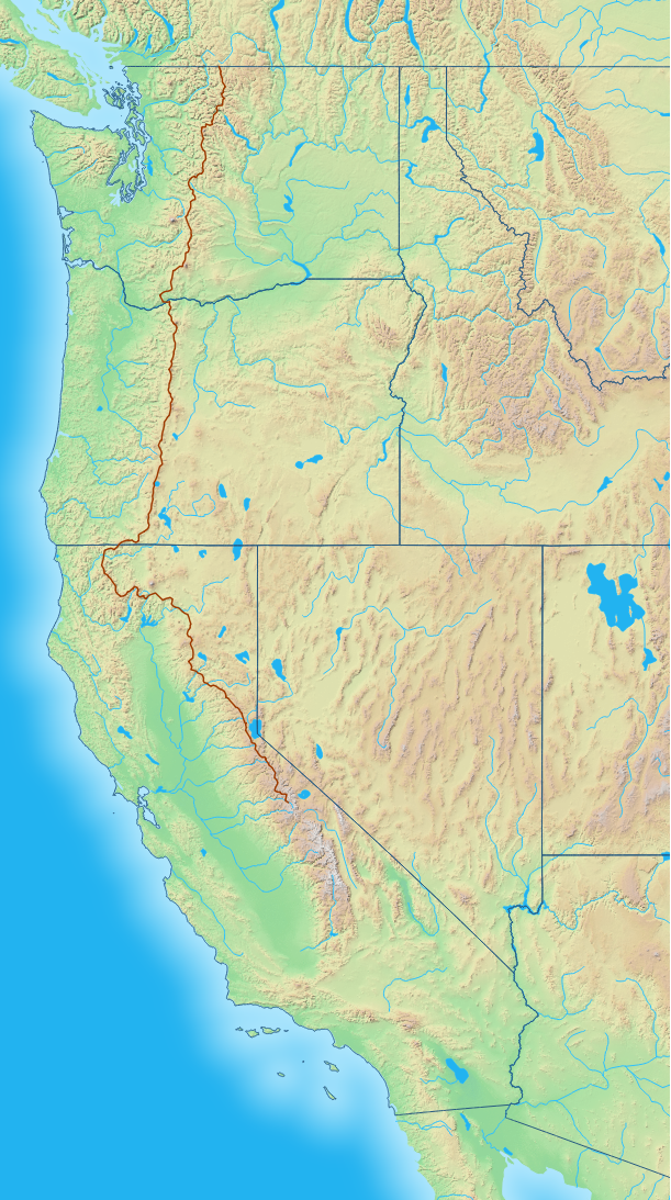
The map above is one I put together using GIS data gathered from several government sources. I have been learning how to manipulate this information in order to enhance the disc golf course maps I publish. I wanted to develop this base map rather than ‘borrow’ one from online. It will come in handy, post hike, to explain where and what she was up to. I can tweak it now as she moves along. I created it by combining a Digital Elevation Model (DEM) of the Western US with shapefiles of the coastline and state borders. The DEM is used to create the color shading of the land and hillshade that shows the elevation changes. I then imported the GPS plots from her Inreach satellite GPS device to show the actual path she has been walking since the beginning of July. It is a work in progress. Notice there are no roads or cities but you can see how mountaness the terrain is along the trail.

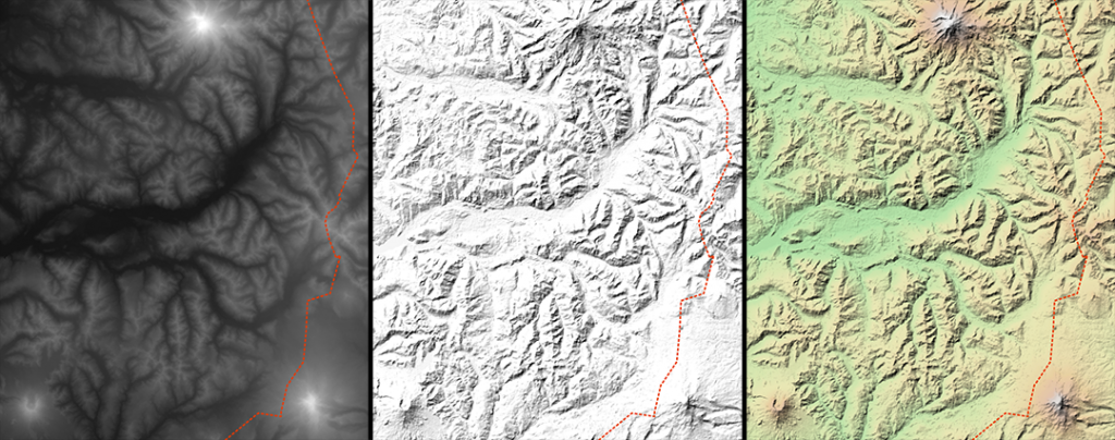
Digital Elevation Models can be rendered to show different aspects of the terrain. The left panel is a grayscale render. Dark pixels are lower elevation and lighter pixels are higher. The three white spots are mountains. Mount Rainier at the top, Mount Adams lower right and Mt. St. Helens lower left. The middle panel is a hillshade render. Imagine crumpling up a sheet of paper and then trying to flatten it out. It will still have creases and if you shine a flashlight across it in a dark room the light and shadows will stand out in much the same way as the mountainous terrain does in this example. The right panel includes the hillshade and adds a color ramp. The ramp is also based on elevation. Green shades for lush vegetation at lower elevations. Yellow shades for grasses on higher meadows. Brown shades for rocky terrain above the tree line and the highest spots in white to represent snow capped mountain tops. Alison’s GPS track is the dotted line running along the right side of each panel.
The package Alison retrieved at the Mammoth Lakes post office contained a warmer sleeping bag and other warm accessories. The Sierra Nevada range has the highest elevations on the trail and therefore some of the coldest temperatures.

This image shows the trail climbing higher. I created it by importing her GPS path and then combining it with the DEM to plot the elevation profile. You can see she is hiking above 10,000 feet quite often now. The Canadian Border is on the far left and Tuolumne Meadows on the far right. Across the top of the chart is the extent of the mountain ranges and across the bottom are the extent of the states. The Columbia River divides Washington and Oregon and is the closest she has been to sea level. I hope these images help with visualizing what she has been up too.
-Richard


20 Responses
Thank you for the update. With the snowstorm in Montana, my thoughts went to Alison. I know she’s not in Montana, but the storm is a reminder that she is in the mountains and winter is coming. Like others have said, great work on the maps and keeping us up to date with her progress.
Alison, keep up the good work and stay safe.
♥️♥️♥️ made it!!!
oh Vicky, it was SO intense, but thankfully we only got squalls and no full on storm. Just as I left the Sierra, the PCT Assoc sent out a notice to hikers not to enter! Show is over, but now the desert awaits! 🐥👣🎒
Glad you are safe!
Thank you for the update, Richard. I am mostly a “lurker” on Alison’s trail blog, but am intensely interested in Alison’s trek and her successful completion of this amazing journey. Love your maps and clear explanations; you are both amazing folks. Hurrah for good spirits and loving teamwork.
best husband ever! ♥️♥️♥️